For my third session of hiking training (which happened in the second week of my training), my uncle (my hiking coach) decided to do the hill path up the Ayer Itam Dam again.
This time, I brought along my camera phone (I have to carry two phones, the one with the camera has 3G capability, so it doubles as my modem for mobile broadband, while the other one is a basic phone for making calls; and yes, somehow, the phone company could not bundle the calling account and the mobile broadband account onto the same SIM card; so much for technological advancement).
***
We started when it was barely light... I had to use the "night mode" of the phone camera because it does not have a flash light.
A few minutes after the first picture, my uncle was already way ahead of me:
As mentioned before, this cemented hill path is used by the residents of that hilly area (a lot of whom are vegetable farmers or orchard owners) as their main access road.
At one point along that cemented hill path, we have to branch off to a still smaller path that will eventually lead to the dam.
After we reached the dam, my uncle decided that we would do extra workout that morning, by walking around the circumference of the dam. The two pictures below show the starting point from the side of the dam where the abovementioned hill path leads to.
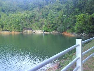
According to some ancient-looking signs, this circumferential road - measuring about 2 km in length, used by the water supply bureau as the service road around the dam - used to be off-limit to the public. But the public's need for a healthy jogging trail and certain orchard owners who access their orchards through this road won the day, and today, we get to enjoy a very scenic jogging trail around what IMHO is a very, very beautiful dam.
Along the circumferential road, you would come across a few lovely streams, all of which empties into the dam.
Fresh air, cool shades, beautiful scenery, what more could you demand from a jogging trail?
After a two-kilometer walk, you will emerge on the other side, which the main tarred road up the dam leads to. And it was decided that we should go down via this tarred road, because the hill path was still considerably wet from the rainfall of the previous night, and might prove treacherous for the downhill hike.
The following picture shows the steepest stretch of the main tarred road, and it's practically a monkey playground.
The building shown in the picture below used to be dilapidated, and I had always found it a pity, that such a beautiful piece of architectural art should one day become a pile of rubble. But thank God, somebody finally realized its worth and turned it into a team-building center, managed by the PBAPP (Penang water supply bureau).
***
Day 3, and it felt exhilarating to be physically active again (I used to hike up to the dam regularly during school breaks when I was in secondary school). :-) Kinabalu: here I come.
Monday, August 24, 2009
Dumbo up the Hills - #2: "Happy Hill" in Jawi
The second session of my hill-hiking training (and the first session for the other four of our group of six - one guy was too busy that day to join us - but it was OK that they did not train as frequently as I did because they are all fitter than I) was at a nameless (to me) hill somewhere in Jawi (belongs to the Penang state also, but is situated on the mainland, in the Southern Perai - formerly Province Wellesley - district).
***
We had agreed a few days earlier that we would go hiking that Sunday (we planned to make it back before the church service at 10:45am), but in the wee hour of that morning, it started raining, and although the rain had stopped some time before we were set to start the ascend. When I called my friend, Vincent (who dragged me into this), he was skeptical about the safety of the climb. "The path might be slippery," he said.
"But you guys haven't started training yet, and we have less than three months to train!" I was eager for more training sessions for myself, which I know they did not need as much as I do. I was the only guy in that group belonging to the obese category, being about 30 kg overweight at that time. "It had stopped raining for quite a long time now, I'm sure if we are careful, we should do all right," I insisted.
So Vincent gave in, and we went off for the climb as scheduled.
***
We started when it was just getting light, and the path appeared to be a motorcycle path for durian orchard owners to reach their orchard up the hill slopes. And the path was much steeper than I had anticipated. Another friend had described it earlier as "a first-gear path", but I was skeptical about his description until I experienced the path for myself, and I had to agree, it was indeed a "first-gear" path.
But I did better than my first climb up the Air Itam Dam a few days earlier, because once I started exercising again, the body sort of woke up from a long slumber and started to kick into a slightly higher metabolic rate.
Well, all along the way, I was bring up the rear, for obvious reason...
The scenery along the climb was mainly that of high-rising durian trees and shrubberies beside the path...
As we neared the highest point we could access, the scenery took on a more garden-like look...
Someone named that hill "Happy Hill" (快乐山; strictly speaking, "山" is mountain, but I have to classify it as a hill, judging from the relatively short climb it took us to get to the highest accessible point). Hikers used to frequent this path, and they even built a shack up there (seen here in the below picture) and serve tea or coffee for free there to hikers (regular hikers took turn to prepare the refreshment, and whoever partook in the food and drinks simply drop money into a collection box according to their individual conscience; this is quite a common practice also in Penang among the regular hikers).
But the place is now derelict.
Nevertheless, the view from the shack was still marvelous...
***
On the way down, I slipped TWICE because of the slipperiness and steepness of the path, and the second time, I landed particularly hard on my derriere, and it continued to ache for a couple of months. It basically did not affect my ability to ascend or descend a slope, but it was hard during those months to find a comfortable posture when sitting down. =.= Yep, my first-hand encounter with sports injury... *sigh*
***
We had agreed a few days earlier that we would go hiking that Sunday (we planned to make it back before the church service at 10:45am), but in the wee hour of that morning, it started raining, and although the rain had stopped some time before we were set to start the ascend. When I called my friend, Vincent (who dragged me into this), he was skeptical about the safety of the climb. "The path might be slippery," he said.
"But you guys haven't started training yet, and we have less than three months to train!" I was eager for more training sessions for myself, which I know they did not need as much as I do. I was the only guy in that group belonging to the obese category, being about 30 kg overweight at that time. "It had stopped raining for quite a long time now, I'm sure if we are careful, we should do all right," I insisted.
So Vincent gave in, and we went off for the climb as scheduled.
***
We started when it was just getting light, and the path appeared to be a motorcycle path for durian orchard owners to reach their orchard up the hill slopes. And the path was much steeper than I had anticipated. Another friend had described it earlier as "a first-gear path", but I was skeptical about his description until I experienced the path for myself, and I had to agree, it was indeed a "first-gear" path.
But I did better than my first climb up the Air Itam Dam a few days earlier, because once I started exercising again, the body sort of woke up from a long slumber and started to kick into a slightly higher metabolic rate.
Well, all along the way, I was bring up the rear, for obvious reason...
The scenery along the climb was mainly that of high-rising durian trees and shrubberies beside the path...
As we neared the highest point we could access, the scenery took on a more garden-like look...
Someone named that hill "Happy Hill" (快乐山; strictly speaking, "山" is mountain, but I have to classify it as a hill, judging from the relatively short climb it took us to get to the highest accessible point). Hikers used to frequent this path, and they even built a shack up there (seen here in the below picture) and serve tea or coffee for free there to hikers (regular hikers took turn to prepare the refreshment, and whoever partook in the food and drinks simply drop money into a collection box according to their individual conscience; this is quite a common practice also in Penang among the regular hikers).
But the place is now derelict.
Nevertheless, the view from the shack was still marvelous...
***
On the way down, I slipped TWICE because of the slipperiness and steepness of the path, and the second time, I landed particularly hard on my derriere, and it continued to ache for a couple of months. It basically did not affect my ability to ascend or descend a slope, but it was hard during those months to find a comfortable posture when sitting down. =.= Yep, my first-hand encounter with sports injury... *sigh*
Subscribe to:
Posts (Atom)