This time, I brought along my camera phone (I have to carry two phones, the one with the camera has 3G capability, so it doubles as my modem for mobile broadband, while the other one is a basic phone for making calls; and yes, somehow, the phone company could not bundle the calling account and the mobile broadband account onto the same SIM card; so much for technological advancement).
***
We started when it was barely light... I had to use the "night mode" of the phone camera because it does not have a flash light.

A few minutes after the first picture, my uncle was already way ahead of me:


As mentioned before, this cemented hill path is used by the residents of that hilly area (a lot of whom are vegetable farmers or orchard owners) as their main access road.

At one point along that cemented hill path, we have to branch off to a still smaller path that will eventually lead to the dam.

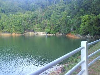
After we reached the dam, my uncle decided that we would do extra workout that morning, by walking around the circumference of the dam. The two pictures below show the starting point from the side of the dam where the abovementioned hill path leads to.


According to some ancient-looking signs, this circumferential road - measuring about 2 km in length, used by the water supply bureau as the service road around the dam - used to be off-limit to the public. But the public's need for a healthy jogging trail and certain orchard owners who access their orchards through this road won the day, and today, we get to enjoy a very scenic jogging trail around what IMHO is a very, very beautiful dam.


Along the circumferential road, you would come across a few lovely streams, all of which empties into the dam.

Fresh air, cool shades, beautiful scenery, what more could you demand from a jogging trail?

After a two-kilometer walk, you will emerge on the other side, which the main tarred road up the dam leads to. And it was decided that we should go down via this tarred road, because the hill path was still considerably wet from the rainfall of the previous night, and might prove treacherous for the downhill hike.

The following picture shows the steepest stretch of the main tarred road, and it's practically a monkey playground.


The building shown in the picture below used to be dilapidated, and I had always found it a pity, that such a beautiful piece of architectural art should one day become a pile of rubble. But thank God, somebody finally realized its worth and turned it into a team-building center, managed by the PBAPP (Penang water supply bureau).


***
Day 3, and it felt exhilarating to be physically active again (I used to hike up to the dam regularly during school breaks when I was in secondary school). :-) Kinabalu: here I come.

No comments:
Post a Comment